
May 8, 2020–In a virtual presentation to the UT Health Trauma Think Tank on Friday, GIS Analyst Nick Medrano explained how the Coalition for National Trauma Research is utilizing the sophisticated mapping platform in a study of the potential survivability of pre-hospital deaths, called MIMIC.
Using data from state public health departments and the Census, Medrano is mapping time to definitive care from injury sites in six different states. While GIS analysis is currently underutilized in this context, during his demonstration, Medrano suggested other potential applications for GIS in trauma studies, citing several recent publications. Think Tank members listening in include trauma care personnel from STRAC, UT Health, the Army Institute for Surgical Research, first-responder groups and other trauma stakeholders in San Antonio.
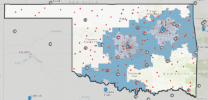
GIS map of Oklahoma showing overall access for the state in 45 and 60 minute intervals for level 1-2 trauma centers.
As part of the MIMIC study, Medrano built a map of the Oklahoma trauma system to assess state-wide access to care. This map includes layers for the road system, level 1 trauma centers, air and ground EMS stations, and points where fatal injuries occurred across the state.
To learn more about how CNTR can assist in incorporating time, distance and injury location data to your next study, contact Research@NatTrauma.org.